DOLOMITI DI BRENTA TRAIL
LONG
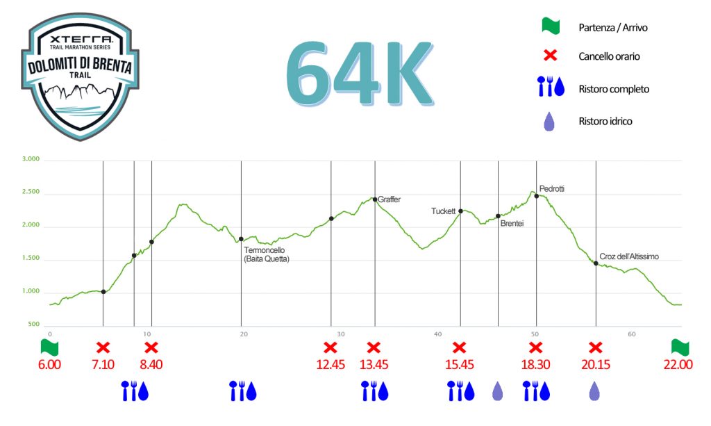
64km - 4.200m D+
Informations
64km con 4.200m D+
Start: 6 am
Maximum time: 16 hours
ITRA points: 3 points


Time gates
Andalo (start of the ascent): 1h 10′ / 07.10 am
crossroad 64k/45K val dei Cavai: 2h 40′ / 08.40 am
crossroad trails 370/301 Passo Gaiarda: 6h45′ / 12.45 am
rif. Graffer: 7h 45′ / 1.45 pm
rif. Tuckett: 9h 45′ / 3.45 pm
rif. Pedrotti: 12h 30′ / 6.30 pm
rif. Croz dell’Altissimo: 14h 15′ / 8.15 pm
Description of the route
The Dolomiti di Brenta Trail starts from the splendid beach of Lake Molveno.
So you reach via Lungo Lago going on for a few hundred meters until you cross the SS 421, turn right and go downhill, reach the bridge that separates Lake Molveno from Lake Bior.
A few meters after the bridge, the SAT 605 path branches off to the left, immediately uphill.
The steep path is also short; in fact, after this first ascent the route continues on a forest road alternating flat stretches with short climbs remaining beside the Rio Lambin.
Just before reaching the SS 421 near Andalo (about km 3.8), you turn to the single track on the right and go up to the parking lot near the departure of the Valle Bianca chair lift; keep to the left of the large car park and follow via Laghet to then descend towards piazza Dolomiti and the state road.
Cross the road at the pedestrian crossing and continue along the sidewalk towards the central square, then turn slightly left and then immediately right to take via Priori.
This leads to the SAT signpost indicating the direction of path 301 towards Malga Spora.
Here a first time gate is placed (about 5,5 km – 1h 10′ maximum)
The climb begins here!
You will soon reach the Masi Pegorar, turn right and shortly left with the SAT 301 path which is immediately very steep.
After the initial stretch, the path sometimes crosses the forest road that climbs towards Malga Dagnola Bassa.
At the 8th km, the forest continues with a left-hand bend, while path 301 continues straight on a single track.
Path 301 now continues alternating uphill sections with some short descents and slight slopes. In some sections there are metal cords to increase the safety of the passage which still remains on an easy and wide path.
In the short route, however, please do not overtake other participants!
This leads to the branch between the path that continues towards Malga Spora (SAT 301) and the one that enters the Val dei Cavai (SAT 302 – 338).
time gate (km 10.5 – 2h 40)
The route then continues in the Val dei Cavai along the path SAT 338. You gradually climb up to the Sella del Montoz (2327 m. – km 13.5).
Now go down on the opposite side looking towards the Val di Non always along the SAT 338 path until you reach Malga Campa (1882 m. – km 16).
Now take the SAT 370 path and shortly face a steep but short climb; continue on beautiful paths up to Malga Loverdina (1771 m. – 18.20 km) and then take the SAT 339 path to Malga Quetta – Malga Termoncello (1886 m. – 19.5 km).
We now continue on the SAT 330 path with alternating slight ups and downs until we reach Malga Flavona (1860 m. – 25.2 km) from where we start climbing along the SAT 371 path.
Attention: shortly after Malga Flavona you climb steeply for a short stretch at the end of which you must stay on path 370 avoiding the 371B which would lead directly to the Groste pass.
Instead, go up the beautiful Campo di Flavona until you cross the SAT 301 path that comes from the Gaiarda pass.
At the intersection of paths 370 and 301 there is a time gate (2189 m. – km 29 – 6h 45 ‘); athletes who do not transit within the time indicated will be invited to return to Andalo in order to allow an easier return.
Back on the SAT 301 path, turn right and head towards the Grosté Pass. The route remains at high altitudes and it presents some short uphill sections.
You therefore reach Passo Grosté (2442 m. – 32.20 km) and descend quickly along the dirt road up to the ref. Graffer (2261 m. – km 33.5).
To ref. Graffer there will be a time gate (7h 45 ‘).
From ref. Graffer therefore descend briefly along the SAT 331 path, then turn left and take the SAT 382 path which, with a beautiful descent, leads to Malga Vallesinella Alta (1681 m. – km. 37.5); near the mountain cottage, turn left towards Rif. Casinei.
Follow the path SAT 317B and reach a slight climb to the ref. Casinei (1826 m. – km 39).
Now keep the left towards the ref. Tuckett: path SAT 317 which first will be the middle of a large forest and then in an open field, which will lead us to the foot of the glacier of Brenta Inferiore which culminates with the beautiful Bocca del Tuckett.
To ref. Tuckett there will be a time gate (2272 m. – km 41.5 – 9h 45′).
We now descend along the SAT 328 path called the Fridolin path, at the end of which we must pay attention to the particular conformation of the ground (oblique stones) which in case of rain or high humidity can become insidious. Also, in this section it is advisable to avoid overcoming other participants by proceeding with caution (for a few meters).
You will then reach the SAT 318 path that goes up the Val Brenta Alta through tunnels dug into the rock and along easy and wide ledges (some short stretches are reassured by a metal cord with a path that remains however easy), until you reach the ref. Brentei (2182 m. – 45.5 km).
We now continue in a fantastic environment between Campanil Basso, Cima Tosa and Crozzon del Brenta with a path (always the SAT 318 path) that crosses the orographic right of the valley (left going up) until we reach a short plateau usually with snow that climbs up to the base of the rocky wall that faces us.
At this point, keep to the left and climb the scree that allows you to get around the equipped section and reach the last snowy slopes and then Bocca di Brenta (2552m. -km 48,5).
The ref. Pedrotti is now in sight. Carefully start descending the first few meters and reach the ref. Pedrotti (2491 m. – km 49,5) where a time gate is provided (12h 30′).
From ref. Pedrotti begins the long descent towards the valley. We therefore follow the path SAT 319. Attention in the first meters. Then you can easily reach the plain below Busazza and the nearby Baito dei Massodi.
In the next section, be careful in case of wet ground.
Along the many paths, you finally descend to the ref. Selvata (1657 m. – km 53.5).
Now take the SAT 340 path, paying attention in the narrowest sections and on the bridges (with cords to facilitate and ensure the descent) until you reach the ref. Croz dell’Altissimo (1491 m. – km 55) where there is a time gate (14h 15′).
Still remaining on the SAT 340 path, we now head towards the ref. Pradel, first on flat road and then slightly uphill (the last one!).
You pass the ref. Pradel (1359 m. – 59 km) and start descending again towards Andalo. After a few hundred meters, you will find signs indicating the direction of Malga Brugnol and Molveno (km 59.5).
Now descend until you come to the upper part of the town of Molveno. Follow Via Belvedere for about one hundred and fifty meters and at the end of the wide hairpin bend, take the narrow pedestrian path on the right which soon leads us to the start of the Pradel cable car.
Now CAREFULLY cross the main road and go down the other side of the road along via Garibaldi which takes you to the center until Piazza S. Carlo (Church).
Now turn left and go down the pedestrian path to the bridge that separates Lake Molveno from Lake Bior; remain on the left of the provincial road and go down to the lake where you immediately turn right to pass under the main road.
Now just travel along the magnificent lake, cross the bridge over the Maso creek and reach the finish area (64 km).